|
EoN Systems, S.A. |
"Next Wave Technology" |
|||||||||
|
|
|||||||||||
|
Geographic Information Systems (GIS)Products: Does your organization need a spatial data solution? Call us - we will help you create a geographic information system (GIS) that integrates your data with a geographic database to facilitate complex and intuitive spatial analysis For Sale: Local, regional, national and international spatial data: High-quality, vector GIS databases and raster imagery: SIG Republic 250k - digital
geographic database of the Republic of Panama derived from a variety of
sources, of which the primary source is the 2001-2002 Instituto Geográfico Nacional
"Tommy Guardia" 1:250,000 scale 12 sheet map set.
SIG Panama 2,500 - all roads, streets, exact buildings footprints at 1,2,500 scale, rivers, streams, coast, bridges, air fields, 100 meter grid, boundaries of Corregimientos, buildings classed by type or function, with beginning and ending addresses of blocks and names of major buildings for the entire Republic of Panama includes all metropolitan and rural areas All the street are digitized as centerlines with the street name attributes and the actual extent of the pavement as well. Includes as an option the year 2000 census data.
SIG City DEM - 5m contours and hill-top spot elevations from 1:5,000 scale maps of Panama Metropolitan area and DEM created from the 5m contours. Purchase orders for SIG City DEM will receive a 10% discount and if they have previously purchased SIG City and they will receive the building heights of all major buildings in the Panama Metropolitan area free. With the DEM and building heights clients will be able to prepare a very precise three-dimensional model of the metro area. Aerial photographs - Digital, georeferenced aerial photographs of Panama City, Canal area and the Republic of Panama
GIS Capabilities - GIS Hardware, software, training, GPS technology, data conversion, data capture, large format printing and scanning, raster-vector conversion, database integration with digital maps, aerial photography with airborne GPS, ortho photographs, high-precision GPS surveying, thematic mapping, complex engineering applications, DEMs, three dimensional modeling and satellite imagery.
GIS Application areas - telecommunications, electric and water utilities, transportation, marketing analysis, government applications, eco-tourism, scientific projects, land surveying, feasibility studies, site location, natural resources management, presentation graphics, commercial applications, distribution systems, engineering, mining, agriculture, health, and emergency response systems. License - We provide pricing for a departmental license for use in a single division or department. The license permits up to three installation on separate computers or installation on a network for up to three simultaneous users. We also provide an enterprise wide unlimited license or we can create a custom corporate license that meets you specific needs. Update - We provide updates to our GIS database from time to time free of charge or at reduced pricing. If we fix geographic features that have defects, we generally offer the update free to existing clients. If we add major features we charge a significantly reduced fee. Distribution and Formats - All the above coverages are distributed on CD ROM in ArcView shape files or ARC/INFO coverages. Other formats are available by special request. Coverages are in UTM coordinate system and referenced to the datum NAD 27 Canal Zone. Training - We also have a sophisticated training facility and provide training in all areas of advanced computing including GIS. We would be pleased to provide a proposal for any scope of training that you may require in either English or Spanish. Guarantee - If you need to review our products again or have any questions we would be pleased to answer them. All of our products represent the highest quality in workmanship and are backed by a 100% satisfaction guarantee. You have 14 days to review our products after purchase and may return them within this time period for a complete refund.
Product Description of SIG Republic 250KDescription SIG Republic 250k is a digital geographic database of the Republic of Panama derived from a variety of sources, of which the primary source is the Instituto Geográfico Nacional "Tommy Guardia" 1:250,000 scale 12 sheet map set. These map sheets are based upon photo-planimetric data from 1982 and represents the most comprehensive available source of spatial data at this scale for the Republic of Panama. From this primary source, we have created a comprehensive national digital spatial data base in ArcView shape file format. The coverages are referenced in UTM coordinate system. SIG Republic includes the following geographic coverages and features:
In all case, SIG Republic makes extensive use of attribute tables to ensure that all significant features have names and appropriate attributes assigned to them. As the maps contains all internal political boundaries provinces, districts and Corrigimientos SIG Republic users can assigned any custom attributes to these political features that they wish and create thematic maps and perform spatial analysis on the attributes that they assign. For example, an agriculture analyst may wish to assign rice crop production figures for each corregimiento and then create a thematic map where color represents a particular range of rice production. SIG Republic, suitable for national and regional analysis, can serve as a GIS database for inserting local data as well. For example, each town is represented by single point however, a user could substitute a complete municipal GIS with streets and buildings within the SIG Republic database. Media and File Format The Digital GIS databases are delivered on CD-ROM in ArcView shape file format for use with products compatible with GIS data from Environmental Studies Research Institute (ESRI). The databases are available in a variety of other formats including AutoCAD .dxf or .dwg, ARC/INFO coverage format or most other vectors formats by special order. User License Agreement All user of SIG Republic will sign a license that delineates their use rights and obligations. The client may install as many copies of SIG Republic within their specific department or organization as indicated by their license agreement. They may make any modifications they wish and to derive maps, products and publications from the digital database. The client, however, is prohibited from transferring the vector digital database to others outside their specific organization or department and from commercializing the data without a specific agreement to do so. In general, the license agreement provides the user of the product with a wide variety of abilities but prohibits the transfer of the digital database to third parties outside their specific organization named in the license agreement. We would be pleased to negotiate any requirements that you may have if it is not covered by the existing standard license agreement. Copies of the license agreement are available on request; anyone interested in purchasing SIG Republic should carefully read the license agreement. Price and Warranty SIG Republic 250k with the above coverages is priced for a single license for a single specific individual, division or department which includes installation on up to 3 multiple machines or on a departmental network server with up to 3 simultaneous users. SIG Republic 250k Enterprise is priced for an agency or institutional-wide license which includes installation on unlimited number of machines or on a network server with unlimited simultaneous users within the institution. Multiple agency pricing is available upon request. Although SIG Republic represents some of our highest quality GIS workmanship, Cyber-Tech does not make any specific claims to accuracy, precision or suitability and the product is sold "as is". The potential client should examine the database personally to make their own assessment of the precision and suitability for a specific application. The media and file structures are guaranteed to be free of technical defects and functional; it will be replaced free of charge if defective. In addition, if the client should damage the original media, we will charge a small fee for a replacement. From time to time updates may be offered to the client free or at a significant discount. For More Information For more information or a demonstration of GIS technology, SIG Republic and our other GIS products, please contact us at the info@trail2.com.
|
.
Contact Information: EoN
Systems, S.A. Web
Site:
Download
EoN Corporate Download
EoN Corporate
Looking
for the Embera Drua Website
Looking for the TCR Tourism, TCR
Strategic Alliance A
Report from the Conference on
Looking
for The
History of the A
Historic Review of the Events and Persons Associated with the Different
Trans-Isthmian Crossings and Routes in Panama by Susan Harp www.trail2.com/embera/history.htm
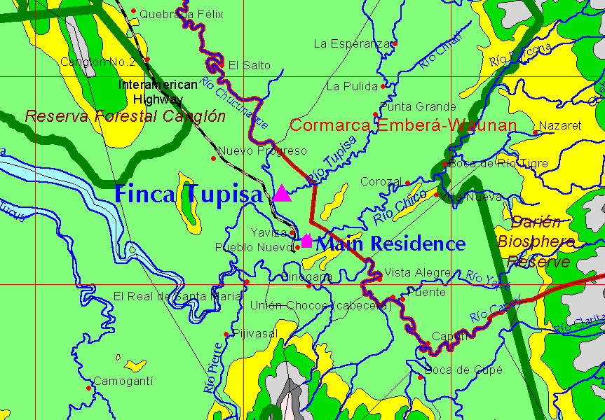
Looking for the Finca Tupisa website? Looking for the Fundación Darien - a Native American pro-community development organization?
Graphics below may be freely used for educational, personal or other non-commercial use provided that the source is explicitly acknowledged. . (c) Copyright
2002, Watch the site for new additional high quality educational graphics in the near future
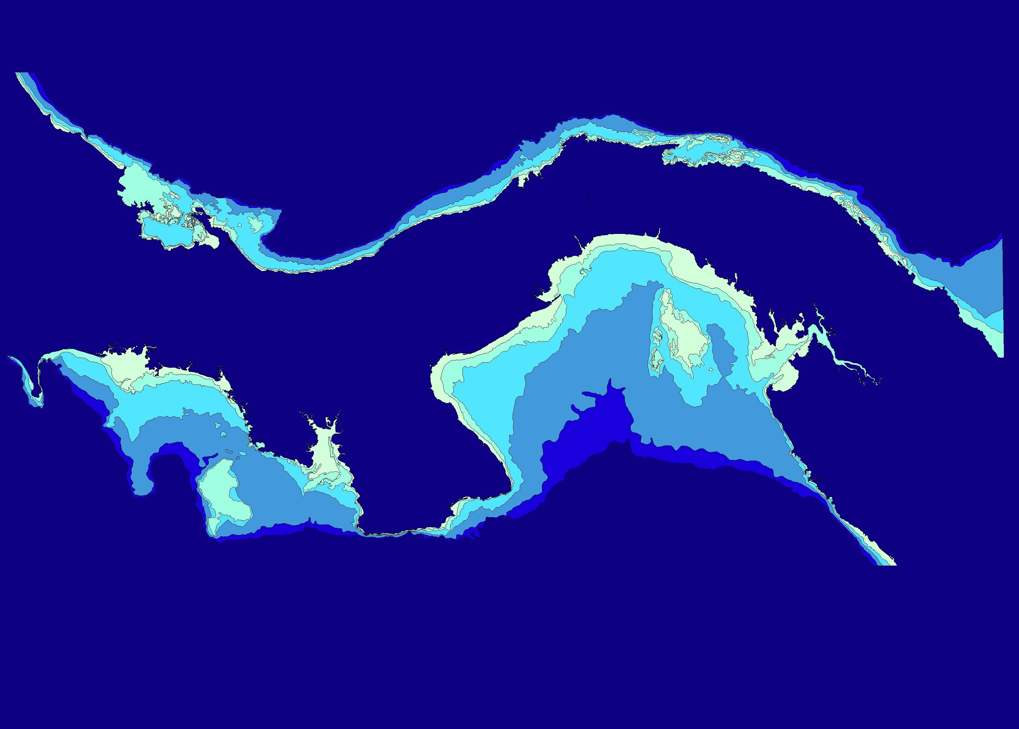
3368x2409 pixels - 389 kb Outline map and ocean depth contours of the Republic of
Panama. Created from
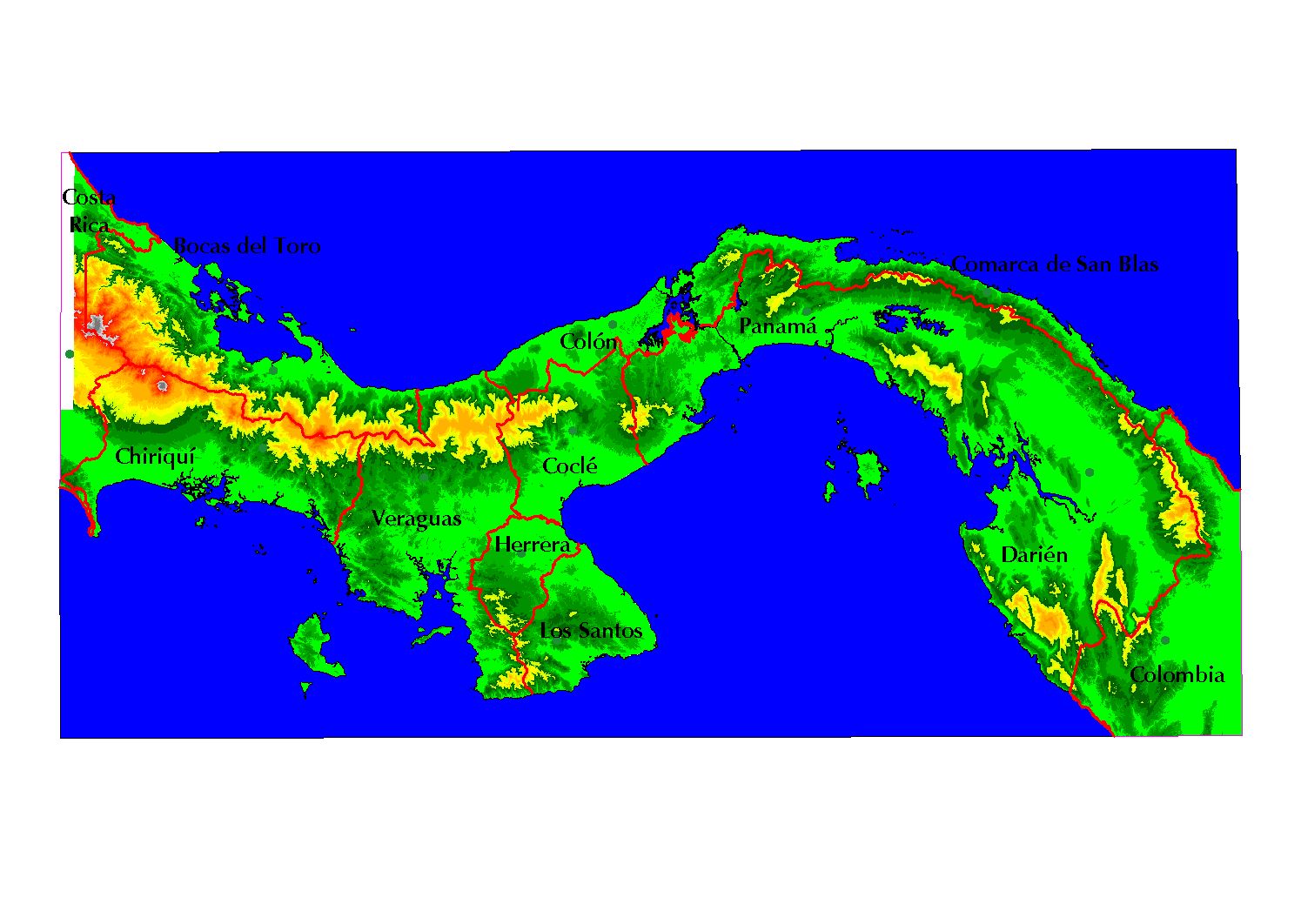
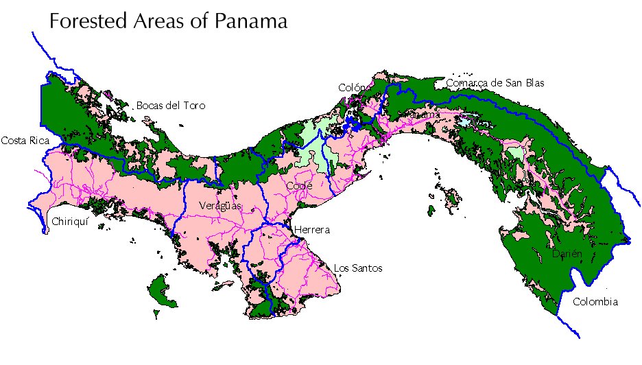
1494x1062 pixels - 200 kb Terrain map of the Republic of Panama. Has older provincial boundaries. Created from SIG Republic 2000
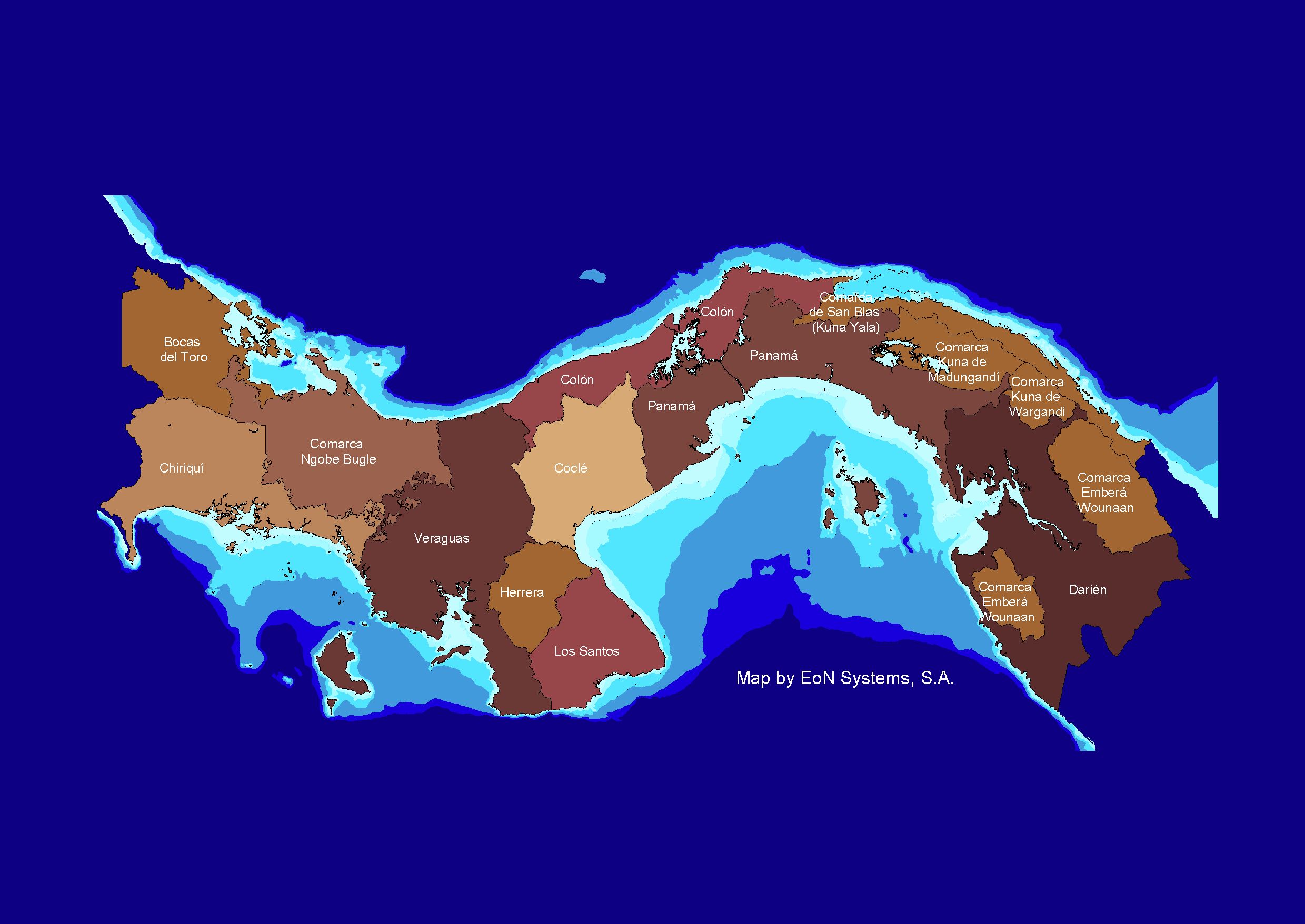
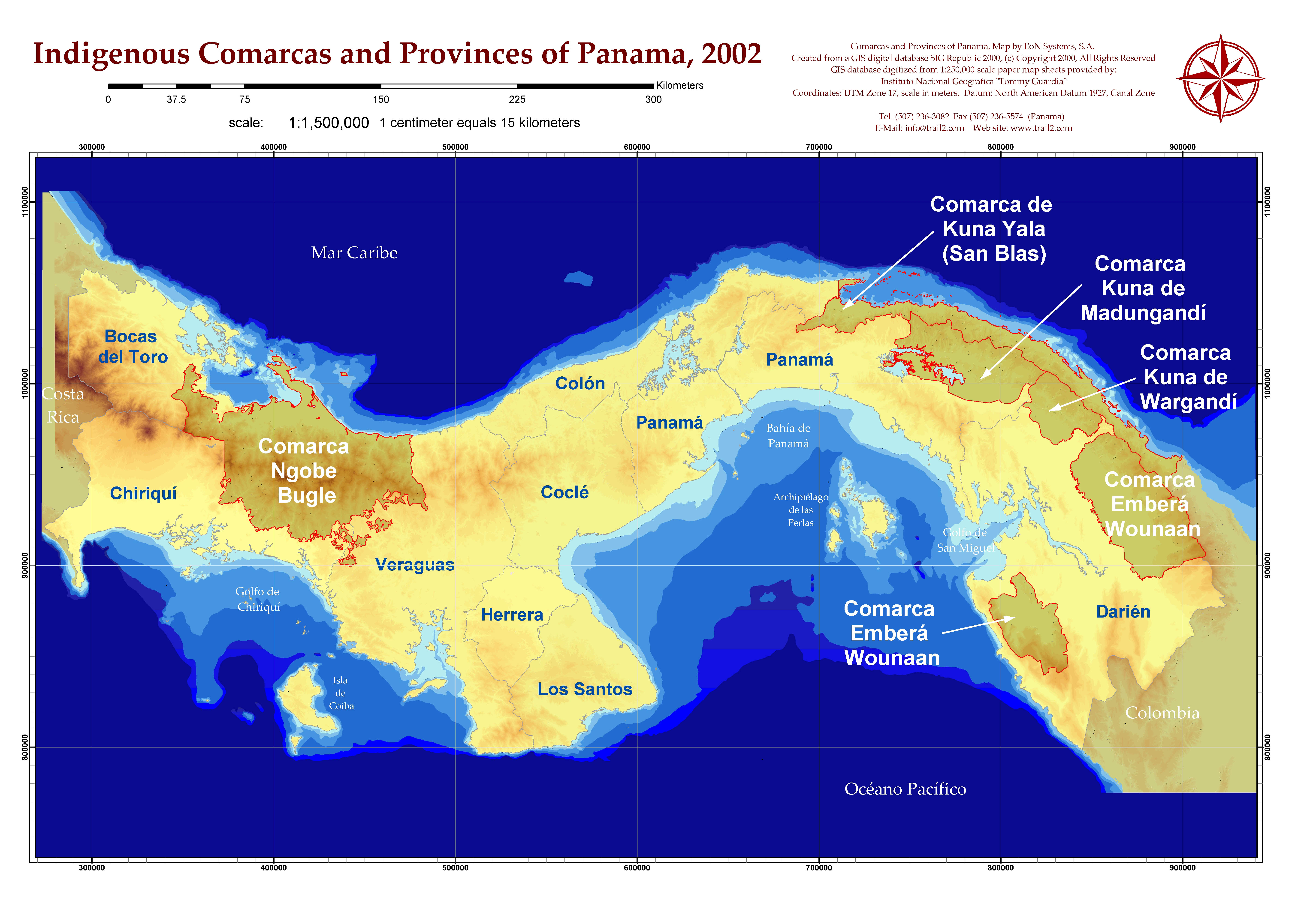
2479x1756- pixels - 300 kb Political Map Provinces and Comarcas with ocean depth
contours of the Republic of Panama. Based upon the latest political
modifications. Great for Powerpoint presentations. Created from
1903x2486 pixels - 704 kb A low resolution image of a 36"x48" poster created for IPAT promoting Tourism, Conservation and Scientific Research. Makes a great 13"x19" color poster for the classroom.
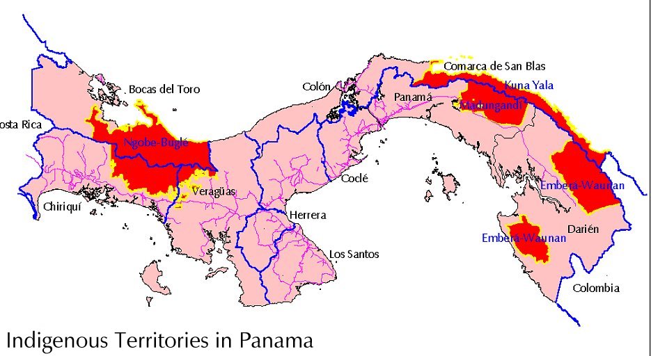
5700 x 3900 pixels - 2 mb A high resolution image of the Provinces and Indigenous
Comarcas of Panama, 2002
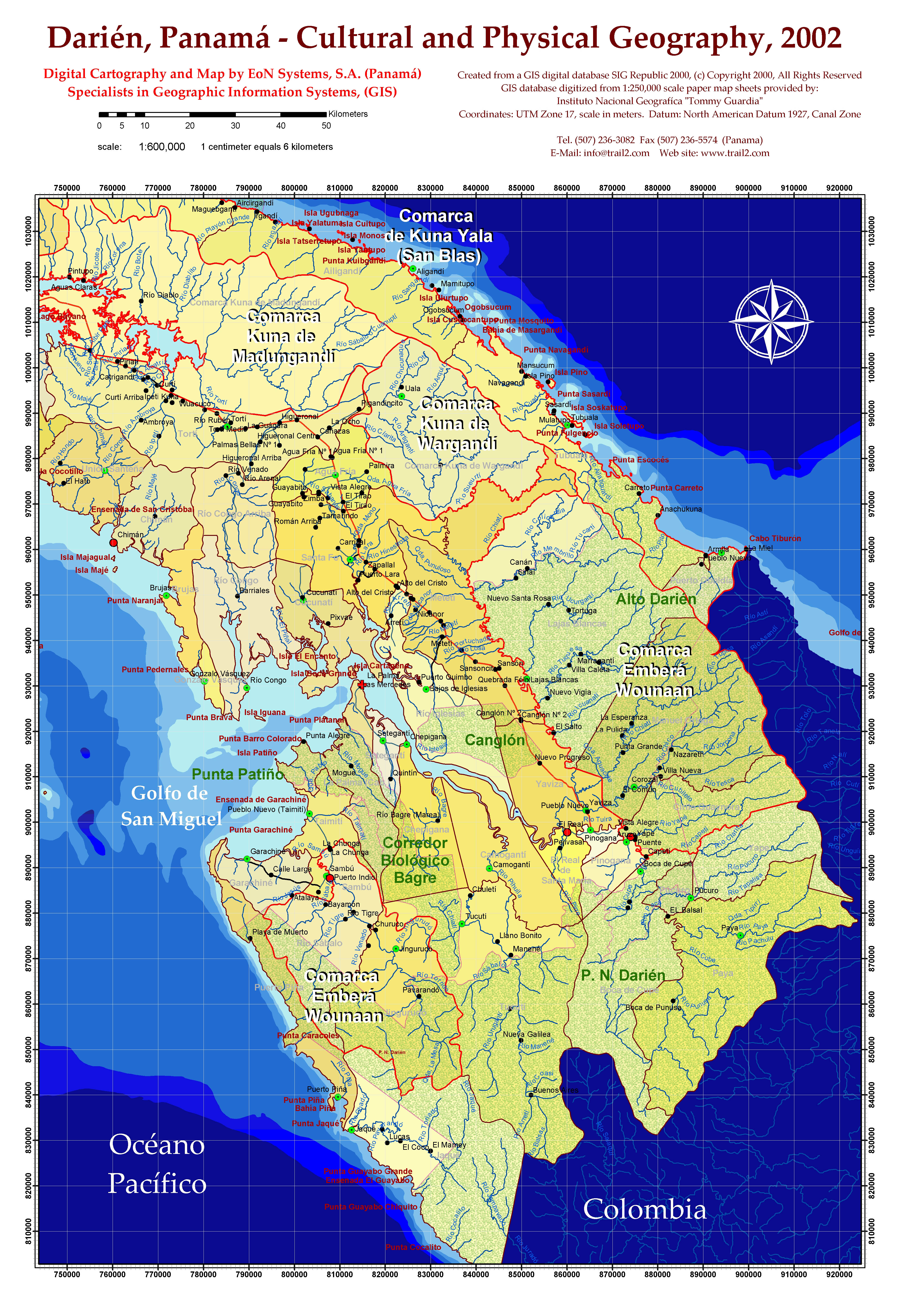
3900 x 5700 pixels - 4.5 mb Darién, Panama - Cultural and Physical Geography, 2002 from 1:250,000 scale sources. | ||||||||||

